Download
Our company is committed to suppor the widespread sharing of scientifically valuable research results and measurement data. Our goal is to enhance and promote domestic geoscientific education and research activities. On this page, you can download our publicly available research and measurement results, as well as the professional and doctoral theses of our current and former employees, and the studies published in scientific journals that highlight their professional journeys.
We hope this initiative helps achieving the above goals. At the same time, we kindly ask for the strict compliance of the written and unwritten rules of scientific publication when using, modifying, and correctly referencing these documents and datasets (or any part thereof).
Maps
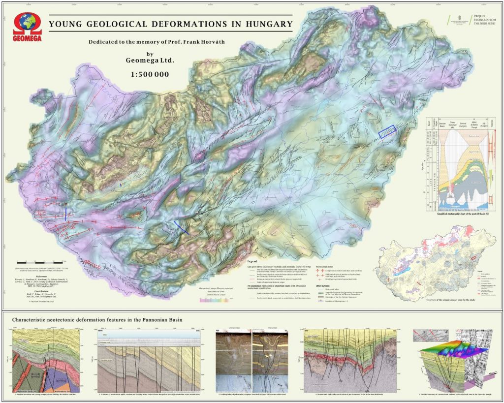
Young geological deformations in Hungary (1:500,000)
NKP project (2018-2022): Construction and analysis of the seismotectonic hazard map of Hungary
Reference: Wórum, G., Koroknai, B., Koroknai, Zs., Fekete-Németh, V., Kovács, G., Tóth, T., 2020. Young geological deformations in Hungary. Geomega Ltd., Budapest https://doi.org/10.17632/dnjt9cmj87.1c
Worum-et-al_2020_Map_Young-defs-HU.pdf
High resolution pdf
Worum-et-al_2020_Map_Young-defs-HU.tfw
Georeferenced image (EOV)
Neotectonic-map_HU.zip
Neotectonic faults, folds and the root zones of faults (.shp)
To access the Neotectonic-map_HU.zip digital vector file, it is necessary to complete a data management statement, which can be downloaded from here. The data will be provided after the completed statement is returned to the worg@geomega.hu email address.
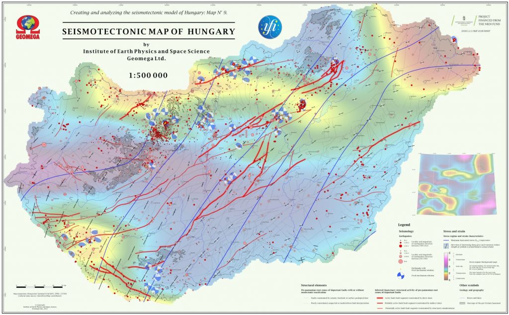
Seismotectonic map of Hungary (1:500,000)
NKP project (2018-2022): Construction and analysis of the seismotectonic hazard map of Hungary
Reference: Koroknai, B., Békési, E., Bondár, I., Czecze, B., Győri, E., Kovács, G., Porkoláb K., Tóth, T., Wesztergom, V., Wéber, Z., Wórum, G. 2023. Seismotectonic map of Hungary, Geomega Ltd., Budapest.
Koroknai-et-al_2023_Seismotectonic-map.pdf
High resolution pdf
Coming soon
Georeferenced image (EOV)
Seismotectonic-map_HU.zip
Root zones of active faults in 3 categories (.shp)
To access the Seismotectonic-map_HU.zip digital vector file, it is necessary to complete a data management statement, which can be downloaded from here. The data will be provided after the completed statement is returned to the worg@geomega.hu email address.
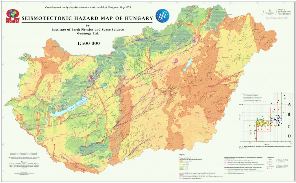
Seismotectonic hazard map of Hungary (1:500,000)
NKP project (2018-2022): Construction and analysis of the seismotectonic hazard map of Hungary
Reference: Kovács, G., Koroknai, B., Győri, E., Németh, V., Balázs, L., Czecze, B., Bondár, I., Wórum, G., Szabó, G., Kegyes-Brassai, O. and Tóth, T. 2023. Seismotectonic hazard map of Hungary, Journal of Maps (in prep.)
Kovacs-et-al_2023_Map_Seismotect-hazard-HU.pdf
High resolution pdf
Kovacs-et-al_2023_Map_Seismotect-hazard-HU.tfw
Georeferenced (EOV)
Books, presentations, closing reports
Tóth, T., Kádi, Z., Wórum, G. és Koroknai, B. 2022. S-hullám szeizmikus mérések alkalmazási lehetőségei a felszínközeli képződmények rétegtani és tektonikai vizsgálatában. Előadás, Magyarhoni Földtani Társulat, MTA PAB Föld- és Környezettudományok Szakbizottság, Radioaktív Hulladékokat Kezelő Kft., előadóülés, Pécs, 2022.12.08
Wórum, G., and Tóth, T. 2009. Development of the abandoned Penészlek gas province: New geological insights into a volcanoclastic gas reservoir and lessons learnt from state of the art exploration techniques. Presentation, Society of Petroleum Engineers (SPE), International Conference, Budapest, Hungary, 16.11.2009.
MSc and Phd theses
Frank Horvath, doctor of academy of science thesis (2007)
A PANNON-MEDENCE GEODINAMIKÁJA, Eszmetörténeti tanulmány és geofizikai szintézis
Reference: Horváth, F. 2007. A Pannon-medence geodinamikája, eszmetörténeti tanulmány és geofizikai szintézis. Akadémiai doktori értekezés, Eötvös Loránd Tudományegyetem, Földrajz- és Földtudományi Intézet, Geofizikai Tanszék , Budapest, 238p.
Koroknai Balázs PhD thesis (ELTE Department of Geology, 2004)
Tektonometamorf fejlődés az Upponyi- és Szendrői-paleozoikumban
Reference: Koroknai, B. 2004. Tektonometamorf fejlődés az Upponyi- és Szendrői-paleozoikumban. Doktori értekezés, Eötvös Loránd Tudományegyetem, MTA Geológiai Kutatócsoport–Általános és Történeti Földtani Tanszék, Budapest, 239p.
Kovács Gábor PhD thesis (ELTE Department of Geophysics, 2013)
Fiatal tektonika és felszínfejlődés kapcsolata az Alpok keleti előterében
Reference: Kovács, G. 2013. Fiatal tektonika és felszínfejlődés kapcsolata az Alpok keleti előterében. Doktori értekezés, Eötvös Loránd Tudományegyetem, Geofizikai és Űrtudományi Tanszék–Természetföldrajzi Tanszék, Budapest, 150p.
Tóth Tamás PhD thesis (ELTE Department of Geophysics, 2003)
Folyóvízi szeizmikus mérések
Reference: Tóth, T. 2003. Folyóvízi szeizmikus mérések. Doktori értekezés, Eötvös Loránd Tudományegyetem, Geofizikai Tanszék , Budapest, 141p.
Wórum Géza MSc thesis (ELTE Department of Geophysics, 1999)
A Mecsek-Villányi térség szerkezete és fejlődéstörténeti eseményei szeizmikus szelvények alapján
Reference: Wórum, G. 1999. A Mecsek-Villányi térség szerkezete és fejlődéstörténeti eseményei szeizmikus szelvények alapján, Szakdolgozat, Eötvös Loránd Tudományegyetem, Geofizikai Tanszék, Budapest, 135p.
Wórum Géza PhD thesis (Vrije Universiteit, 2004)
Modelling of fault reactivation potential and quantification of inversion tectonics in the southern Netherlands
Reference: Worum, G. 2004. Modelling of fault reactivation potential and quantification of inversion tectonics in the southern Netherlands. PhD Thesis, Netherlands Research School of Sedimentary Geology (NSG), Publ. No. 20040606, ISBN 90-9018395-7, Vrije Universiteit, Amsterdam, 152p.
Publications
Cloetingh, S., van Wees, J.D., Ziegler, P.A., Beekman, F., Tesauro, M., Förster, A., Norden, B., Kaban, M., Hardebol, N., Bonté, D., Genter, A., Guillou-Frottier, L., Ter Voorde, M., Sokoutis, D., Willingshofer, E., Cornu, T. and Worum, G. 2010. Lithosphere tectonics and thermo-mechanical properties: An integrated modelling approach for Enhanced Geothermal Systems exploration in Europe. Earth-Science Reviews 102(3), 159–206pp, DOI:10.1016/j.earscirev.2010.05.003.
Fodor L., Gerdes A., Dunkl I., Koroknai B., Pécskay Z., Trajanova M., Horváth P., Vrabec M., Jelen B., Balogh K. and Frisch W. 2008. Miocene emplacement and rapid cooling of the Pohorje pluton at the Alpine-Pannonian-Dinaridic junction, Slovenia. Swiss Journal of Geosciences, vol. 101, Supplement 1/ September, 2008, pp. 255-271. DOI: 10.1007/s00015-008-1286-9
Haas, J. (ed), Budai, T. (ed), Csontos L., Fodor, L., Konrád, Gy., Koroknai, B. 2014. Magyarország prekainozoos medencealjzatának földtana. Magyarázó „Magyarország pre-kainozoos földtani térképéhez” (1:500 000). [Geology of the pre-Cenozoic basement of Hungary. Explanatory notes for „Pre-Cenozoic geological map of Hungary”, 1:500 000]. Publ. Geol. Geoph. Inst. Hungary, pp. 1-73.
Horváth, F., Koroknai, B., Tóth, T., Wórum, G., Konrád, Gy., Kádi, Z., Kudó, I., Hámori, Z., Filipszki, P., Németh, V., Szántó, É., Bíró, A., Koroknai, Zs., Földvári, K. és Kovács, G. 2019. A „Kapos-vonal” középső szakaszának szerkezeti-mélyföldtani viszonyai és neotektonikai jellegei a legújabb geofizikai vizsgálatok tükrében. Földtani Közlöny 149(4), 327-349pp, DOI: 10.23928/foldt.kozl.2019.149.4.327.
Koroknai B., Árkai P., Horváth P., Balogh, K. 2008. Anatomy of a transitional brittle-ductile shear zone developed in a low-T meta-andesite tuff: a microstructural, petrological and geochronological case study from the Bükk Mts. (NE Hungary). Journal of Structural Geology, 30(2), pp. 159-176, DOI: 10.1016/j.jsg.2007.10.007
Kovács, G., Fodor, L., Kövér, S., Molnár, G., Raáb, D., Telbisz, T. and Timár, G. 2015. Verification of Late Miocene to Quaternary structural control on landforms: a case study with comprehensive methodology from a low hilly area (western Pannonian Basin). Austrian Journal of Earth Sciences, 108(2), 82–104. DOI: 10.17738/ajes.2015.0015.
Magyar, I., Sztanó, O., Sebe, K., Katona, L., Csoma, V., Görög, Á., Tóth, E., Szuromi-Korecz, A., Šujan, M., Braucher, R., Ruszkiczay-Rüdiger, Zs., Koroknai, B., Wórum, G., Sant, K., Kelder, N. and Krijgsman, W. 2019. Towards a high-resolution chronostratigraphy and geochronology for the Pannonian Stage: Significance of the Paks cores (Central Pannonian Basin). Földtani Közlöny 149(4), 351-369pp, DOI:10.23928/foldt.kozl.2019.149.4.351.
Maros, Gy., Koroknai, B., Palotás, K., Fodor, L., Dudko, A., Forián-Szabó, M., Zilahi-Sebess, L., Bán-Győry, E. 2004. Tectonic analysis and structural evolution of the north-eastern Mórágy Block (A Mórágyi-rög ÉK-i részének tektonikai elemzése és szerkezetalakulása). MÁFI Évi Jelentése 2003-ról, pp. 371–394.
Maros Gy., Koroknai B., Palotás K., Musitz B., Füri J., Borsody J., Kovács-Pálffy P., Kónya P., Viczián I., Balogh K., Pécskay Z. 2010. Brittle Fault Zones in the Mórágy Granite: New Structural and K–Ar Data (Törészónák a Mórágyi Gránitban: új szerkezeti és K–Ar-adatok). A MÁFI Évi Jelentése 2009, pp. 91–112.
Poros Zs., Molnár F., Koroknai B., Lespinasse M., Maros Gy., Benkó Zs. 2008. Fluidzárvány-sík és repedésrendszer vizsgálatok alkalmazása granitoid kőzetek fluidáramlási rendszereinek rekonstrukciójában III. A Bátaapáti (Üveghuta) radioaktív hulladéktároló telephely kutatófúrásaiban végzett vizsgálatok eredményei. [Application of studies on fluid inclusion planes and fracture systems in the reconstruction of the fracturing history of granitoid rocks III: Results of studies in drillcores from the radioactive waste depository site Bátaapáti (Üveghuta)]. Földtani Közlöny, 138/4, pp. 361–382.
Worum, G., van Wees, J.D., Bada, G., van Balen, R.T., Cloetingh, S. and Pagnier, H. 2004. Slip tendency analysis as a tool to constrain fault reactivation: A numerical approach applied to 3D fault models in the Roer Valley Rift System (southeast Netherlands). Journal of Geophysical Research (109), B02401, doi:10.1029/2003JB002586.
Worum, G., Michon, L., van Balen, R.T. van Wees, J.D., Cloetingh, S. and Pagnier, H. 2005. Pre-Neogene controls on present-day fault activity in the West Netherlands Basin and Roer Valley Rift System (southern Netherlands): role of variations in fault orientation in a uniform low-stress regime. Quaternary Science Reviews 24(3), 473-488pp, DOI:10.1016/j.quascirev.2004.02.020.
Worum, G. and van Wees, J.D. 2017. High-resolution quantitative reconstruction of Late Cretaceous-Tertiary erosion in the West Netherlands Basin using multi-formation compaction trends and seismic data: implications for geothermal exploration. Acta Geodaetica et Geophysica 52(1), DOI:10.1007/s40328-017-0196-6.
Zámolyi, A., Kovács, G., Székely, B. és Timár, G. 2010. A Bakony vetőmintázatának morfometriai vizsgálata és az ebből levonható néhány tektonikus geomorfológiai következtetés [A morphometric analysis of the fault pattern of the Bakony Mountains: some tectonic geomorphological implications]. Földtani Közlöny, 140, 439–453pp.