This section is available only in Hungarian!
GINOP-2.1.2-8-1-4-16-2017-00025
Vállalatok K+F+I tevékenységének támogatása kombinált hiteltermék keretében
Projekt alapadatok:Kedvezményezett neve: GEOMEGA Földtani és Környezetvédelmi Kutató-Szolgáltató Kft.
Projekt címe:„Altalaj vizsgálatok és a mérnöki tervezéshez szükséges talajmechanikai paraméterek in situ meghatározása roncsolás-mentes módszerrel”
Projekt azonosítószáma: GINOP-2.1.2-8-1-4-16-2017-00025
Forrás megnevezése: ERFA
Projekt megvalósítási helyszíne: 7673 Kővágószőlős, hrsz. 0222/22.
Projekt költségvetése: 203 428 055 Ft
Megítélt támogatás: 111 885 429 Ft
Támogatás mértéke: 55 %
Projekt megvalósítás időszaka: 2018.03.01. – 2020.08.31.
A projekt tartalmának rövid összefoglalása:
A projektcél egy Ny-Európában és a tengerentúlon már ismert vibroszeiz technológia által megvalósítható, kevéssé elterjedt eljárás továbbfejlesztése és hazai gyakorlatba ültetése.
Az eljárással a Föld 0-100 m közti rétegéről kapunk 3D információt, ami valamennyi építőipari, infrastrukturális beruházás, számos bányászati, környezet- és vízvédelmi tevékenység alapvető és elengedhetetlen feltétele.
A szolgáltatás 4 szeizmikus módszer ötvözéséből áll össze. Az integráció egyik fő motivációja a mérnöki gyakorlatban szükséges szilárdsági paraméterek megbízható származtatása az elérhető legjobb termelékenységgel és költséghatékonysággal. Ezen paraméterek mutatják meg, hogy adott anyag bizonyos erőhatásra, nyomásváltozásra milyen mértékű deformációt szenvedhet el. Építőipari szempontból a legfontosabb talajjellemzők, megbízható ismeretük a munkálatok, sőt a tervezés megkezdése előtt már alap. Célunk egy olyan szeizmikus rutineljárás bevezetése a hazai piacra, mely minden nagyobb építési beruházást és infrastrukturális fejlesztést megelőz.
A fenti paraméterek 10-100 m mélységközben hibahatáron belül meghatározhatók fúrásokkal, de ezek több tekintetben korlátozottak. Pontszerű információt adnak rossz térbeli felbontással, visszafordíthatatlan beavatkozással, környezetterheléssel járnak, az alapozásnál kritikus, laza üledékekből felépülő, felső 10 m leképezésére pedig kevéssé alkalmasak. Az új technológia használatával egy beruházás során kevesebb, „kalibráló” fúrás mélyítésére lesz szükség mégis jóval pontosabb térbeli adatrendszer állítható elő.
Ma hazánkban csak hidraulikusan működő, csak nyomáshullám előállítására képes vibroszeiz eszközök állnak rendelkezésre. Ezek meghibásodásai, karbantartási munkái rengeteg időt és pénzt emésztenek fel, az esetlegesen kiömlő, nagynyomású olaj pedig balesetveszélyes és környezetszennyező. Az új technológia által nem csak a kezelhető mérnöki problémák spektruma bővül, hanem csökken a környezeti elemek igénybevétele, az ökológiai lábnyom is.
Szerződészám: 2018-1.2.1-NKP-2018-00007
Magyarország szeizmotektonikai veszélyeztettségi térképének megalkotása és elemzése
A társadalom biztonságát meghatározó tényezők közül különös figyelmet érdemelnek a természeti körülményekben bekövetkező változások. Hirtelen bekövetkező, gyorsan lezajló és megakadályozhatatlan földi eseményeket jelentenek a földrengések, amelyek a Föld szeizmikusan nagy aktivitású és népsűrűségű területein óriási katasztrófák előidézői lehetnek. A Pannon-medence és benne Magyarország szeizmikus aktivitása kis-közepes szintű, de nem elhanyagolható mértékű. Több nagy földrengés volt az utóbbi évszázadokban, amelyeket történelmi feljegyzések vagy műszeres megfigyelések és részletes kárfelmérések alapján jól ismerünk. A mérsékelt szeizmicitás nem jelenti azt, hogy minden földrengés mérsékelt erősségű lenne, csak azt, hogy a nagy rengések ritkák, visszatérési idejük sokezer év. Ezért a meglévő földrengés katalógusok alapján előrejelzésük bizonytalan. Fontos tehát, hogy Magyarország területére minél pontosabb választ adjunk a „hol” kérdésére.
A klasszikus szeizmológiai eljárások a múlt ismert eseményei alapján determinisztikus vagy probabilisztikus metodikával készítenek előrejelzéseket. Az utóbbi évtizedekben azonban jelentős haladás történt a Föld dinamikájának megértésében, beleértve a földrengések kialakulásának folyamatát és mechanizmusát. Ezzel párhuzamosan látványosan fejlődtek az aktív vetők térképezésére alkalmas geofizikai mérések, a szeizmogén szerkezetek pontosabb azonosítására képes hipocentrum meghatározó eljárások és új űrgeodéziai módszerek születtek a felszínmozgások nagypontosságú mérésére. E korszerű ismeretek és technikák szélesebb alapokra helyezik a szeizmikusan veszélyes területek kijelölését. Ennek szellemében szeizmotektonikus veszélyeztetettség térképet szerkesztünk, ami tartalmazza Magyarország neotektonikus térképén az aktívnak talált vetőket és vetőkhöz kapcsolt szeizmogén szerkezeteket.
A földrengések elleni védekezés leghatékonyabb módját a földrengésbiztos építkezés jelenti. A Magyarország területére vonatkozó szeizmikus zóna beosztás európai keretben lett kidolgozva (Eurocode-8, MSZ EN 1998-1) 1998-ban. Megadja azt, hogy 50 év alatt 10%-nál nagyobb valószínűséggel várható legnagyobb földrengés milyen megrázottságot (horizontális gyorsulást) okoz az alapkőzeten. Ezt az értéket át kell számolni a felszínre és így kapható meg a mérnöki tervezés számára mértékadó dinamikus igénybevétel. Az átszámításhoz ismerni kell az altalaj 30 méter vastagságú rétegének átviteli tulajdonságait, alapvetően a laza rétegátlagos S-hullám sebességét (VS30). Ezt hagyományosan az építési (alapozási) területen mélyített fúrások magmintáin végzett labor mérésekkel, penetrációs szondázásokkal és speciális geofizikai vizsgálatokkal lehet meghatározni. Ezeknek a költséges és hosszadalmas eljárásnak a kiváltására számos kísérlet történt világszerte. A legszellemesebb módszert az Amerikai Földtani Intézet (USGS Open-file Report 2007-1357) alkotta meg, kimutatván, hogy a topografikus gradiens (lejtőszög) értéke jó korrelációt mutat a felszíni laza réteg átlagos nyíró(S)-hullám sebességével. Magyarországon a módszert geofizikusok kísérleti jelleggel már alkalmazták néhány helyen, és arra következtettek, hogy a tektonikusan aktív területekre vonatkozó korreláció jó közelítést ad Magyarországra is, de nagyobb területekre való kiterjesztéshez további vizsgálatokra és kalibrációkra van szükség.
E vizsgálatokat és kalibrációkat szeretnénk megvalósítani a szeizmotektonikus térképünk alapján meghatározott aktív vetőzónában és geomorfológiai környezetében mért elegendő számú S-hullám szelvényezéssel és komplex értelmezéssel. Ezzel megteremtjük a validálás módszertanát és az országos kiterjesztés tudományos alapját. A kidolgozásra kerülő szeizmotektonikai térkép és laza réteg korrekciós térkép alapként szolgál minden építészeti tervező számára a városépítészettől kezdve a kiemelt beruházások megvalósításáig. Így a projekt kutatási eredményei az ipar számára (műszaki tervezés, építőipari kivitelezés) is hasznosíthatók lesznek.
VEKOP-1.2.6-20-2020-01244
A mikro-, kis- és középvállalkozások modern üzleti és termelési kihívásokhoz való alkalmazkodását segítő fejlesztések támogatása
Projekt alapadatok:Kedvezményezett neve: GEOMEGA Földtani és Környezetvédelmi Kutató-Szolgáltató Kft.
Projekt címe:„Mérőeszközbeszerzés a Geomega Kft-nél”
Projekt azonosítószáma: VEKOP-1.2.6-20-2020-01244
Forrás megnevezése: ERFA
Projekt megvalósítási helyszíne: 1093 Budapest, Közraktár u. 20/A. 2. em.2., hrsz: 37095/23/A/24
Projekt költségvetése: 25.680.150 Ft
Megítélt támogatás: 17.976.105 Ft
Támogatás mértéke: 70 %
Projekt megvalósítás időszaka: 2020.09.29. – 2020.12.21.
A projekt tartalmának rövid összefoglalása:
Cégünk a kezdetek óta foglalkozik mérnökgeofizikai vizsgálatokkal, kis mélységű földtani, vízföldtani és környezetvédelmi kutatások geofizikai támogatásával. E vizsgálatok a felszín alatti rétegek több különböző fizikai paraméterének mérését jelentik, melyek közül sokoldalúan használható alapvető módszerek a fajlagos elektromos ellenállás mérése, és az elektromos vezetőképesség mérése. Ezekhez szerztünk be 1-1 eszközt. 1 db 10 csatornás mérést lehetővé tévő ARES II/10 műszert és 1 db CMD Explorer típusú elektromágneses vezetőképesség mérőrendszert.
Az ARES II/10 műszer beszerzése kiemelt profilunkban a vízi geofizikai mérésekben komoly előrelépést jelent. Az új rendszer mérési sebessége biztosítja a folyamatos vontatás mellett történő vízi mérést is, ez növeli a mérési hatékonyságot. Az új eszközzel mérési kapacitásunk, rugalmasságunk bővül.
A CMD Explorer mérőrendszer a legfelső 7 m mélység hatékony és pontos felmérését teszi lehetővé, használata jelentős fejlődési potenciált rejt magában a felszínközeli kőzetrétegek vizsgálatánál.
Our company considers the training of experts, the discussion of professional experience, and the appropriate data visualization to be important for the further development of geophysics. To this end, several conference lectures, presentations and professional reports were presented by Geomega Ltd.:
The presentation of the XXXVI. Országos Vándorgyűlés from 2018 can be found through the following link: http://hidrologia.hu/vandorgyules/36/word/0712_toth_tamas.pdf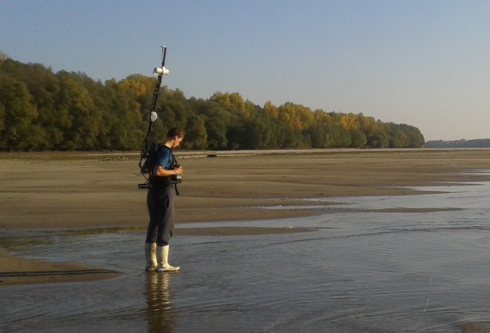
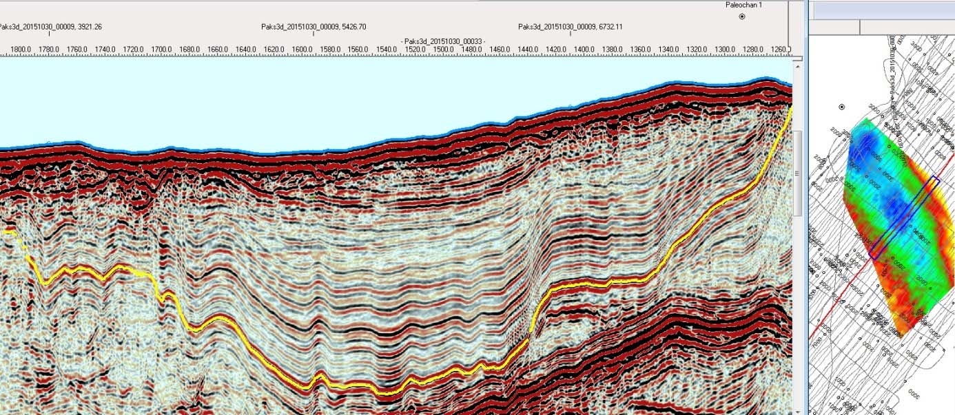
Interpretation of the Paks-3D seismic survey shot in 2014, and mapping of the structural elements in the area were important tasks during the geological investigations of the nuclear power plant site at Paks, Hungary. In the exploration report prepared by Geomega Ltd, we have constructed structural maps in the 50km radius area around the site for various geological formations. The youngest mapped formation was the Algyő Formation, whose fault polygons depict those faults that crosscut the Pannonian layers in the vicinity of the Paks Nuclear Power Plant.
Taking into account tectonic stability and earthquake hazard considerations in the broader area of the nuclear power plant, it is essential to know, whether the fault systems crosscutting the Pannonian sediments also penetrate into the Quaternary strata, and what degree of activity they had during the Quaternary. To evaluate this we performed the following high resolution surface geophysical surveys:
- GPR georadar and electromagnetic measurements
- Combined refraction seismic and multi-electrode surveyings
- S-wave reflection seismic surveying
- High resolution seismic measurements on river Danube
The aim of the water seismic measurements was to get a shallow geological knowledge of the surrounding area significantly formed by the Danube, and to map the fracture systems that may intersect them. In the course of this, a former abandoned Danube riverbed, perpendicular to the current one, was identified, the fine sediments of which show young deformation due to an ancient earthquake (seismite).
In several of the geoelectric and S-wave seismic sections, we also identified young deformations, namely shallow faults affecting Holocene layers.
A 3m deep trench excavated on the section most affected by the faults fully confirmed what was seen on the seismic lines. Off-site surveys thus provided a wealth of useful information that made it easier to interpret the results of on-site measurements conducted in environments heavily affected with anthropogenic impacts. Electromagnetic (EM) mapping and georadar (GPR) surveys helped to prepare field investigations, select drilling and sounding sites by exploring artificial inhomogenities (buried objects, pipelines, cables) in the near-surface, anthropogenic layers. The same EM and GPR results provided useful near-surface data for the interpretation of further exploration tasks, such as S-wave reflectin seismic surveying.
To facilitate the correlation between the drilling and sounding points within the site, combined multi-electrode profiling, P-wave refraction seismic and S-wave shallow reflection seismic measurements were performed along the sections connecting the various drilling points. These surface geophysical measurements provided additional data for the geotechnical studies about the uppermost layers of the Quaternary and Upper Pannonian sediments.
Similarly to the off-site surface geophysical measurements, he on-site investigations provided additional information for geological-tectonic knowledge as well as for the assessment of the subsoil quality of the site.
The official document (in Hungarian language) summarizing the exploration activity is available at the following link: PDF
In addition to the Pannonian Basin, Geomega Ltd. has also carried out hydrocarbon exploration activities in many regions of Europe. Outstanding among these are the Dutch and British sectors of the North Sea (Southern and Northern Permian Basin), where we provided various services to our clients in the period of 2010-2015. Tasks included exploratory / evaluative deep subsurface mappings, complete hydrocarbon geological evaluations of exploration blocks and abandoned fields, 3D numerical reservoir modelings as well as reservoir geological and depositional environment reconstructions based on integrated seismic attributes, core data and petrophysical analysis of well logs.
High-quality 3D seismic data systems were usually available to perform the tasks, but in many cases their interpretation was complicated by the fact that the primary reservoirs within the Zechstein, Rotliegend and Carboniferous formations were buried at great depths under varying thicknesses of Permian salt layers. Due to the salt tectonics and to the laterally as well as vertically highly variable seismic velocities partly attributed to it, depth conversion methods based on advanced 3D velocity models had to be used.
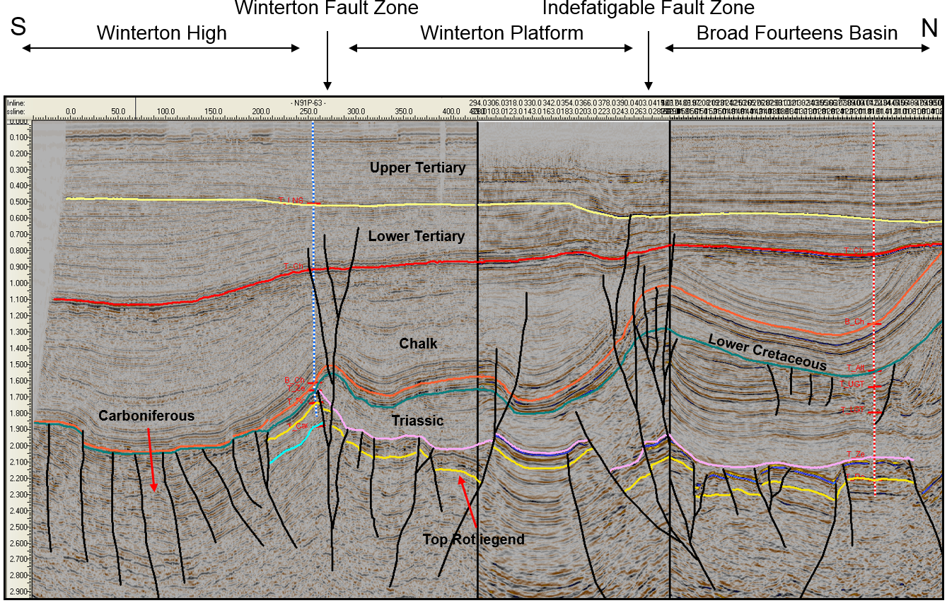
In many cases, the exploration areas were located on the edges of hydrocarbon provinces with significant hydrocarbon discoveries, therefore the maturation history and migration conditions of the area had to be modeled to be able to perform a well-established risk analysis of the identified prospects. In areas characterized by laterally significantly changing reservoir qualities, it was necessary to reconstruct the depositional environment and to spatially map the reservoir quality, using integrated methods based on 3D seismic attributes, core data and well log evaluations.
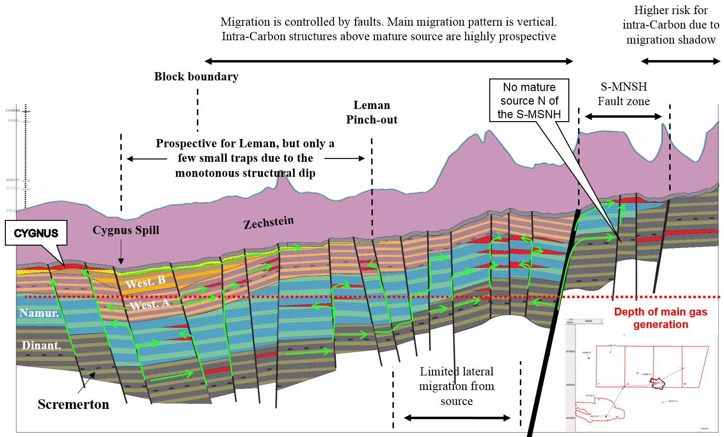
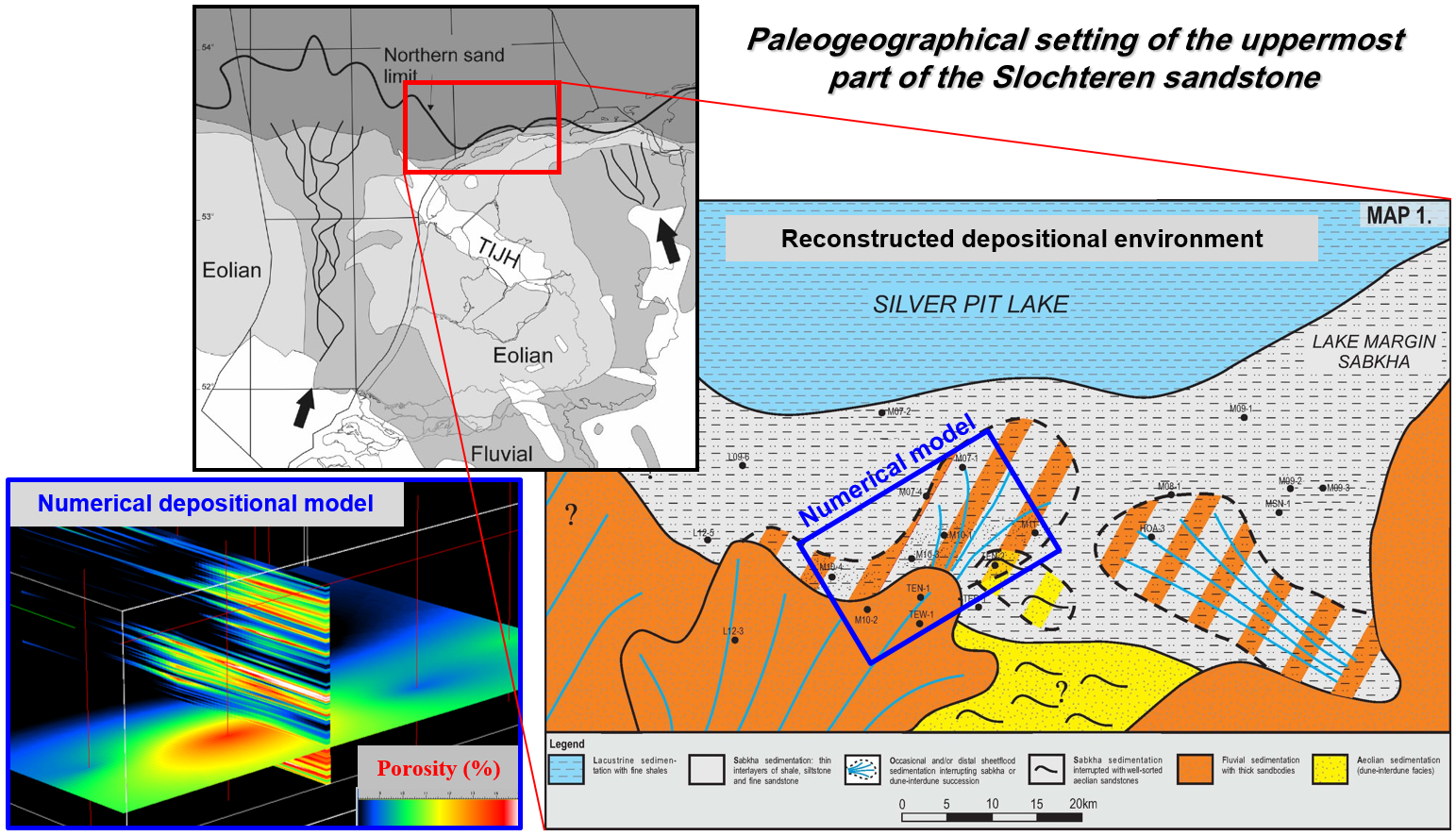
In the case of the M11/1 Rotliegend gas field offshore Holland, our task also included the construction of a 3D numerical reservoir model of the entire gas field. This model was generated using 3D seismic and drilling data and used by partner companies for their numerical reservoir engineering calculatons aiming for field optimization and production forecasting.
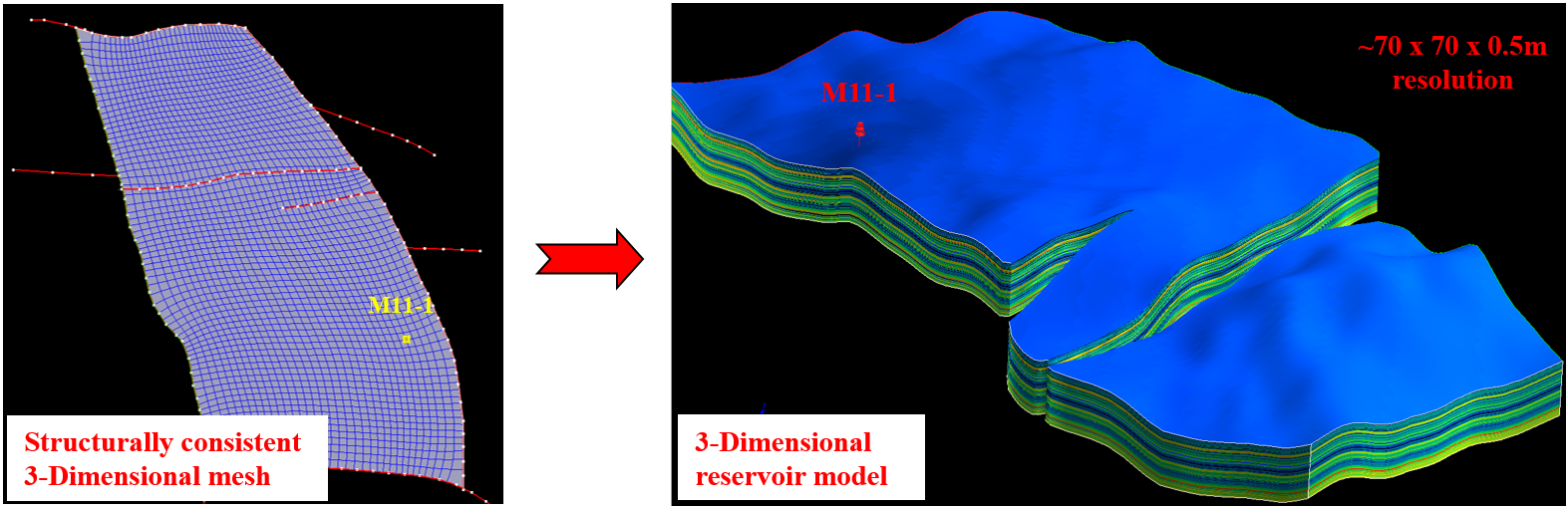
Our services have greatly contributed to a well-established geological model of the area and to the determination of the business value of the given project, and ultimately contributed to the successful involvement of additional business partners.
It is well known that due to its high temperature gradient the Pannonian basin is a favourable area for geothermal energy production. This natural resource is further enhanced by another advantage of the area; the knowledge and experience resulting from decades of geological, hydrogeological and hydrocarbon exploration.
Planning and execution of geothermal projects starts with the understanding and detailed mapping of subsurface stratigraphy, hydrogeology and tectonics. As a first step areas with significant potential for geothermal energy utilization can be selected based on the results of geological and geophysical investigations. Selection of the most suitable technology on the other hand depends not only on subsurface hydrogeology, but also on present day and future geographical and economical considerations. All this is topped with environmental and legal considerations, which provide the framework for sustainable and well controlled energy utilization.
The main goal of the DRAVA-GEO project (HUHR/0901/2.1.3./0006; http://www.geo.dravamedence.hu/en/fooldal), financed by the European Union and led by Somogy Megyei Önkormányzat, is to introduce this multidisciplinary task through the evaluation of the cross-border area of Drava basin across the Hungarian-Croatian border. Drava basin is not only an excellent study area because of its subsurface geology, but at the same time areas along the Croatian border are the primary target areas for development. It is high time to reconsider resources and possibilities in these areas. As part of these reconsiderations both traditional and new areas should be considered. Geothermal energy may become one of the new key areas.
Geomega Ltd. participated in the DRAVA-GEO project as an implementating partner, our task was to construct the structural model of the area as well as to assess its geothermal resources.
The main geothermal prospects of this area are related to reservoirs in Upper Pannonian sandstones, Lower Pannonian turbiditic sandstones, Middle Miocene Lithothamnium-bearing limestones, Mesozoic (mainly Triassic) carbonates and fractured metamorphic basement rocks.
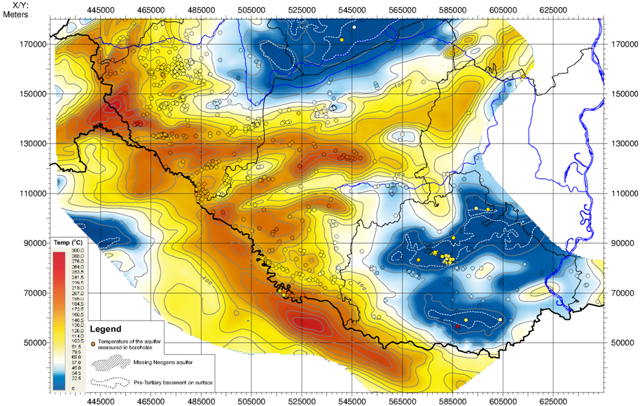
Geomega Ltd. acquired 2000km of 2D seismic sections and the most important well data from the MBFH (Hungarian Mining and Geological Authority). This was completed by collection of water flow tests and measured temperatures from selected new wells. It was followed by a complex evaluation of this large database. The evaluation was geophysically oriented and consisted of digitalization of paper based well logs, construction of SMT Kingdom seismic project and stratigraphic interpretation of 2D seismic sections. This resulted in good knowledge of the different geothermal reservoirs in southern Transdanubia.
Further interpretation of the seismic data was carried out in order to arrive at a new tectonic map of the study area. The map and the seismic sections show that the main tectonic elements related to the formation of the basin have been the subject of neotectonic reactivation. Active faults exert a major control on the fluid flow and heat transfer systems of the basin. New temperature and thermal gradient maps have been constructed to check this relationship and to outline areas where hydraulically open fault systems are available.
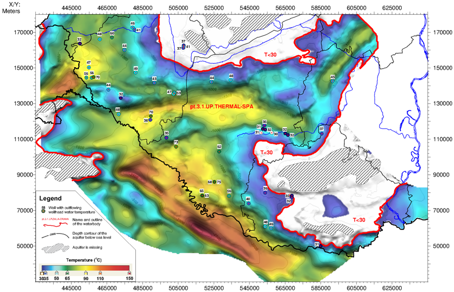
We have arrived at the main conclusion that southern Transdanubia and the adjoining Croatian territories exhibit major potential for geothermal utilization. The main value of this work is given by the acquired knowledge and created database, which together can offer optimal projects for geothermal installations in the study area.
Feltöltés alatt…
In industrialized countries, varying levels of pollution from legal and illegal activities have been accumulated in rivers, canals, lakes and harbors. They have been treated as sludge comprehensively since the ’50s. The contaminated riverbed, although probably absorbed the larger proportion of the pollutant in the past, continues to release it into the water, which naturally affects the quality of drinking water. The extent of pollution is often astonishing; Rhine River transports 13 tonnes of cadmium to the North Sea each year, 8 tonnes of which are derived from the Dutch industry. (Rhine, along with other surface waters, supplies 65% of the drinking water in the Netherlands.)
The recognition of these phenomena made it necessary to assess pollution, in many cases to perform remediation. Numerous local surveys have been carried out using manual sampling devices, but these are only point-like data that may indicate the quality of the mud as a first approximation, but cannot be used to evaluate the spatial extent of the contamination. Remediation work can only be performed in a cost-effective manner, which requires high-resolution measurements.
According to the first estimations, € 700 million would have been required for the measurements, however with the help of new, combined measurement technologies and procedures, not only more detailed results were obtained, but also at a much lower cost. The amount remaining for remediation thus remained much higher.
The aim of the Geowaters project, in which Geomega Kft. managed the works as the lead coordinator:
- Development of an integrated geophysical method, which can be used to measure and monitor the quantity and quality of the young and presumably polluted sediments
- Implementation of various destruction-free measurmenets techniques
The two best-used technologies were high-resolution shallow water seismics and underwater GPR radar surveying. Geomega Ltd. still plays a leading role in these areas today, and the added value of combining the two methods, although technically challenging, provided a more advanced environmental perspective during the project.
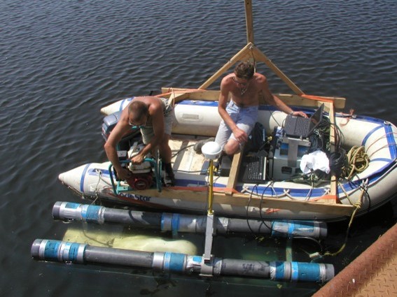
The experience and results of the measurements have contributed and still continue to contribute to the goals of ensuring a sustainable water supply, the traceability of sources of pollution, the development of monitoring strategies and the development of new, innovative tools for analysis.
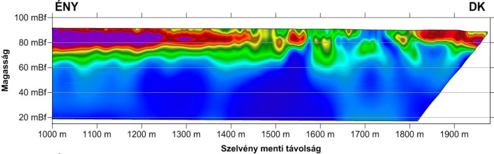
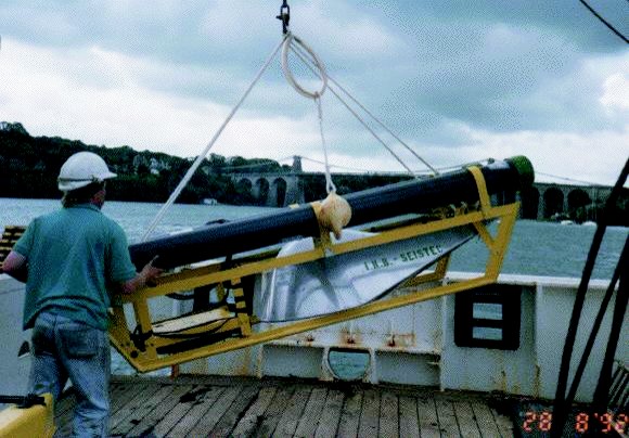
At the beginning of the 2000s, Geomega Ltd. also participated in the preparatory works of the M4 metro line in Budapest. In order to conduct the subway under the Danube, water seismic measurements were carried out to accurately map the riverbed in the vicinity of the Liberty Bridge.
Multi-channel as well as a dense network of ultra-high-resolution single-channel seismic measurements were performed during the project, from which a pseudo-3D data set could be produced. The dataset proved to be well suited for setting up the main tectonic elements and fault map of the area, as well as providing critical information for the tunneling phase.
The results have shown that the main structural elements are in the direction of NW-SE, being in agreement with the tectonic characteristics of the wider area.
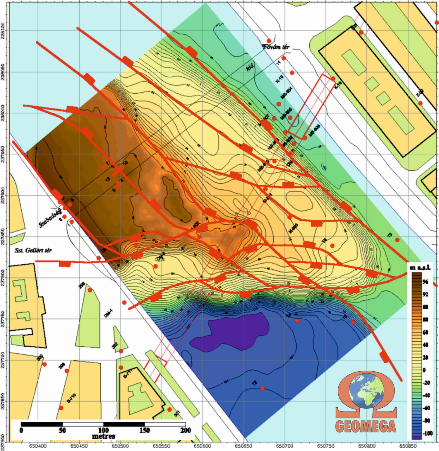
The ultra-high resolution water seismic measurements have also shown the remnants of the old Franz Joseph Bridge blown up by the germans in World War II and a triassic dolomite block emerging from the bottom of the river. This block, which has since been called the „Dearth-rock” (Ínség-szikla), can emerge from the water at the low water level of the Danube, as has already happened before. As the river washed the riverbed above the rock, it was necessary to place rocks at the bottom of the riverbed during tunneling of the subway, in order to prevent drilling heads working under high pressure from blowing up the top of the tunnel under construction.
So, with seismic measurements in the water, the karstified dolomite block has been avoided, and tunneling has been safely implemented.
Available publication: PDF

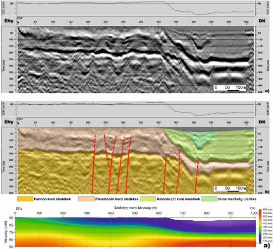
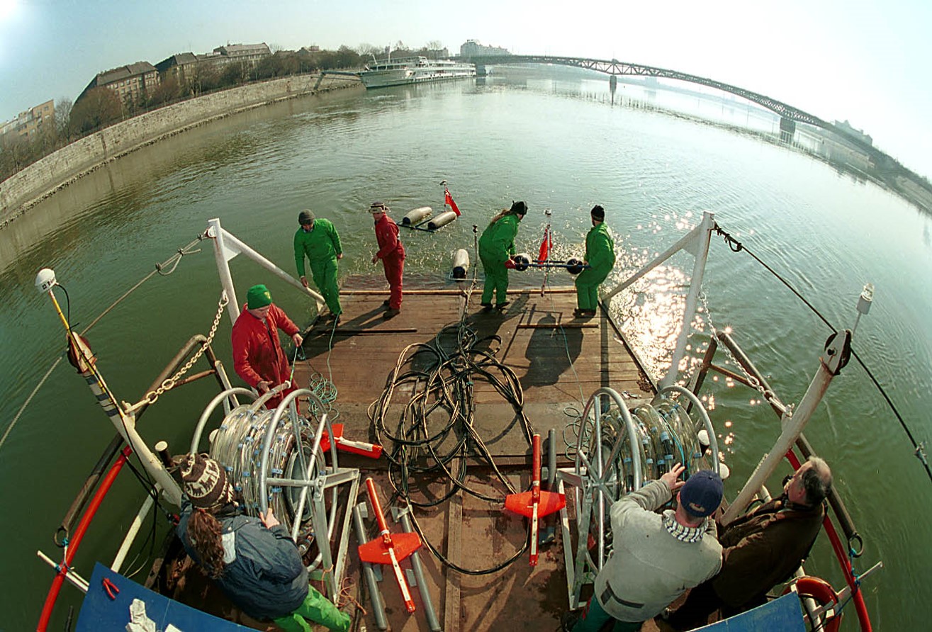
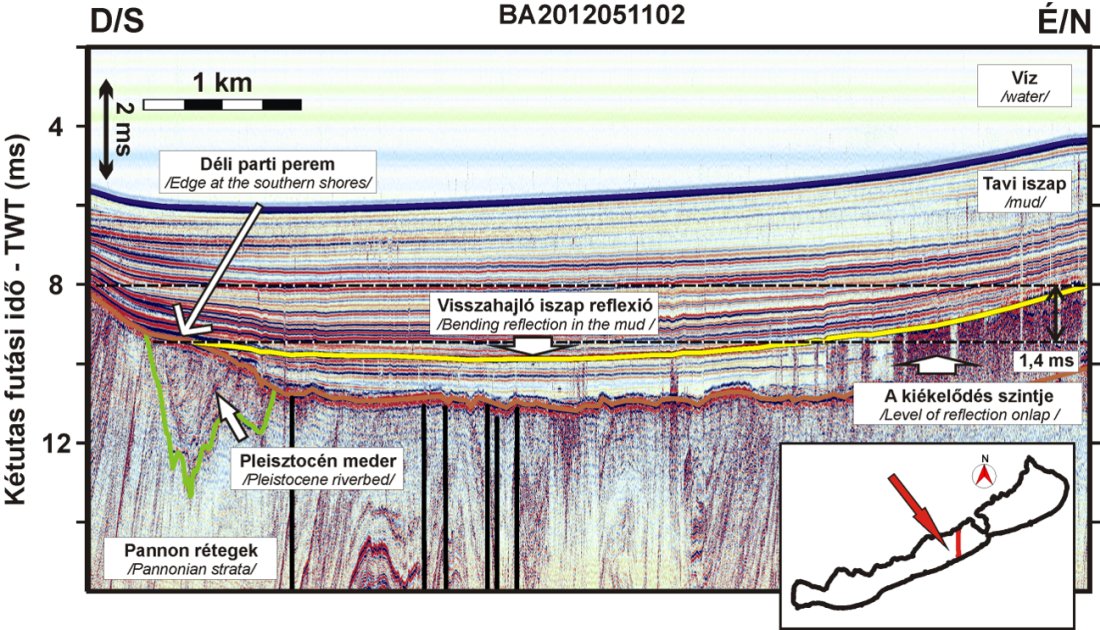
Mainly between 1997 and 2007, high-resolution seismic measurements were carried out in Lake Balaton in cooperation between the Department of Geophysics of Eötvös Loránd University and Geomega Ltd. This resulted in the ELTE-GEOMEGA Balaton high resolution seismic dataset, which provided useful data on the Pannonian layers under the Holocene sediments.
The surveying got into a more intense phase in 2003 with the launch of the OTKA project entitled „Development of integrated research methods for the geophysical examination of quaternary environmental conditions”. The ultra high resolution seismic imaging was primarily aimed at mapping the layers and structural elements of Pannonian age under the Siófok Basin, but due to the dense measurement grid and accurate GPS positioning, the data could be used for mapping the lake bed and the holocene sediment thickness.
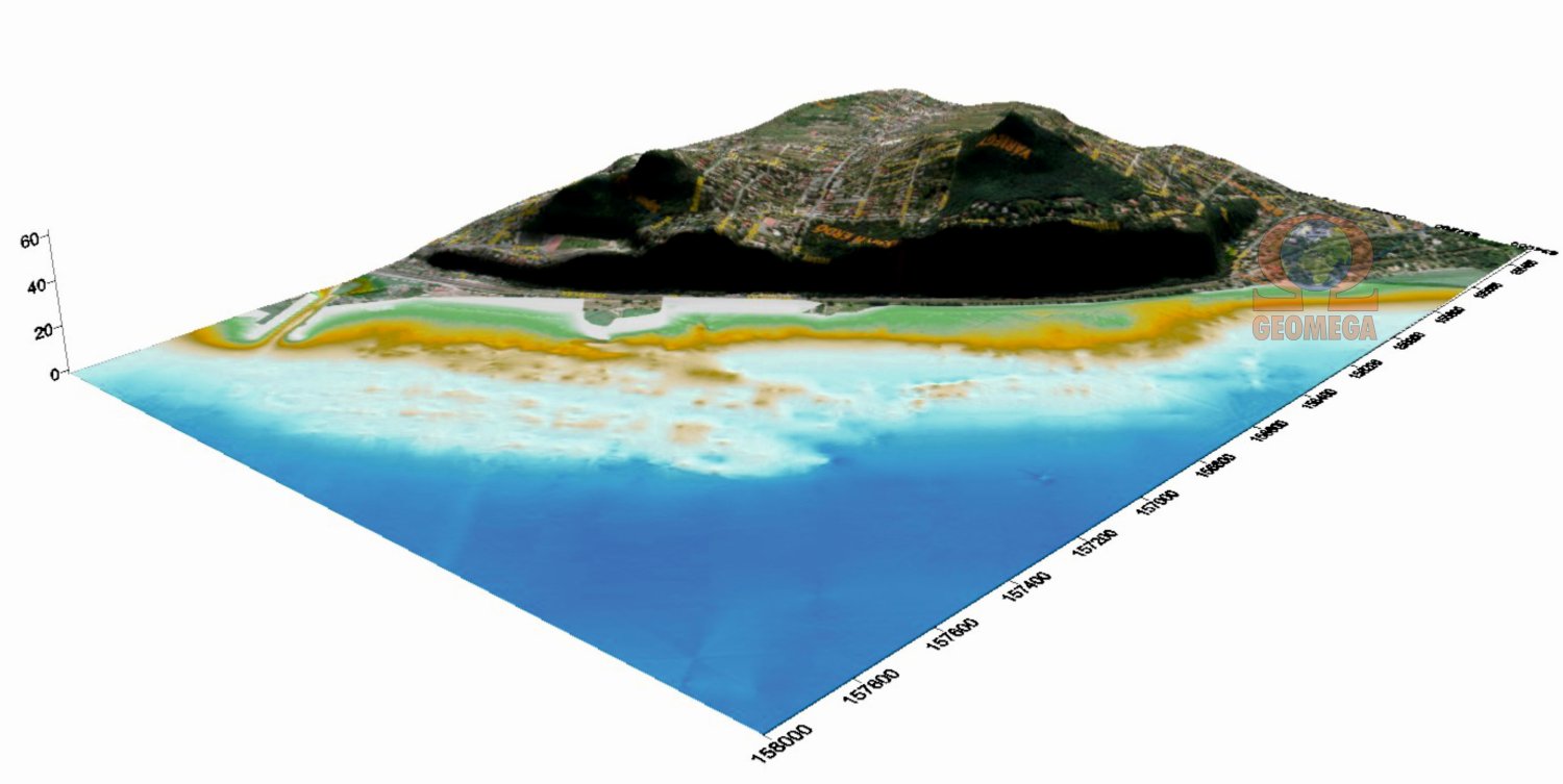
Water depth and sediment thickness mapping of Lake Balaton served several purposes simultaneously. The degree and distribution of sediment accumulation in the lake has been a long-term research topic, and there is a great interest for the problem of mud formation by the general public too. However, since Lake Balaton is located in a tectonically rather active and not fully understood geodynamic area, broader conclusions can also be drawn from the study of the geomorphological conditions of the lake bed.
Using this dataset, many scientific documents (publications, theses, doctoral theses, etc.) have been born, whichled geoscientists closer to the understanding of the evolution of the lake.
Interpretation of Ferenc Visnovitz
2013- today: Geophysical surveying of river crossings of gas pipelines. FGSZ Zrt.
2006- today: Riverbed surveying of the Danube at the Paks Nuclear Power Plant. FTV Zrt.
2019: Water seismic surveying of river fords on the Danube at Helemba, Ebed and Nyergesújfalu. VIZITERV Consult Kft.
2019: Water seismic surveying of river fords on the Danube at Százhalombatta, Dunaföldvár, Göd and Gönyű. BME – Vízépítési és Vízgazdálkodási Tanszék
2019: Riverbed surveying on the Danube near the Baráka ford. FTV ZRt.
2019: Riverbed survey on the route of the planned Danube bridge (1641+350 rkm). FTV ZRt.
2018: Water seismic survey of open gravel-pit lakes within the Majosháza III. mining plot. Pannon Ásvány Kft.
2018: Geophysical riverbed surveying on the Danube between the Szentendre and Margaret islands. VITUKI Hungary Kft.
2017: Lake bottom survey on lake Lupa. Lupa Strand Kft.
2011-2016: Riverbed surveying of the Danube at the Mohács harbor. Mohácsi Városgazdálkodási és Révhajózási Nonprofit Kft.
2007-2008: Combined (water seismic- GPR radar – geoelectrical tomography) geophysical surveying of the Ráckeve-Soroksár-Danube and its tributaries. Árvízvédelmi és Belvízvédelmi Központi Szervezet Kht.
2006: Lake bed surveying and sediment thickness mapping on the Szalkszentmárton-II gravel-pit lake. KAVICS-KER Kft.
2005: Archaeological exploration of the route of the planned pipe-laying in the Szeged section of the Tisza, in the 172.8 rkm section, with single-channel, ultra-high-resolution seismic surveying. SZEVIÉP ZRt.
2005: Seismoacoustic measurements on the Danube, North of the Northern Railway Bridge. Kulturális Örökségvédelmi Hivatal
2004: Archaeological exploration of the Tisza between Szeged Belváros and Felsőváros bridges using single-channel, ultra-high-resolution seismic surveying. Octopus Tengeri Kutató Egyesület
2002-2003: EU GeoWaters project, Geomega Ltd. as project coordinator, www.geowaters.com
2001: Seismic investigations in the vicinity of Budapest Metroline 4 under the Danube. BKV Rt. DBR Metro Projekt Igaztgatósága
2000: Single-channel seismic surveying on the Rhine in the Netherlands. Dutch Geological Survey
1999: High-resolution seismic profiling and engineering geophysical sounding in the Adony and Százhalombatta area on the 1596.1-1596.5 and 1617.5-1617.9 rkm sections of the Danube. MOL Plc. Kőolaj- és Földgázszállítási Üzletág.
1997: High-resolution seismic survey on the Danube near Kismaros. Közép-Duna-völgyi Vízügyi Igazgatóság.
1996: High-resolution seismic experimental measurements on river water in the section of the Tisza between Szeged and Szolnok. MOL Plc.
1995: Acoustic surveying on the Danube. Paksi Atomerőmű Rt.
2020: Geoelectric and electromagnetic investigation of the main protection lines of the Ipolydamásd- Letkés-Ipolytölgyes flood protection area. Közép-Duna-völgyi Vízügyi Igazgatóság
2019: Combined geophysical survey along the planned T181, T200, and T232 tunnel sections of the M100 motorway. EFERTE Kft.
2019: Investigation of the internal structure of the Veovača valley dam near Vares. NATURAQUA Környezetvédelmi Tervező és Szolgáltató Kft.
2019: Investigation of the extent of water pollution around the Kővágószőlős I. mine and tailings dump by geophysical methods. BVH Bányavagyon-hasznosító Nonprofit Közhasznú Kft.
2018: Combined geophysical exploration on the Róka-hill of Üröm. Petik Mérnöki Szolgáltató Kft.
2018: Combined geophysical exploration on the slopes of the Herend gravel-pit lake. Petik Mérnöki Szolgáltató Kft.
2018: Combined geophysical exploration of the soil environment near the main building of the Hévíz Lake Bath. Hévízgyógyfürdő és Szent András Reumakórház KHT.
2015: Geoelectric investigation of the dams bordering the Széll Kálmán square (Vérmező and Várfok streets), Budapest II. district. EFERTE Kft.
2014: Geoelectric investigation of the characteristics of the acquitard in the designated area of the municipal waste dump near Pásztó. EFERTE Kft.
2013: Geoelectric investigation of the waterbase in the designated area of Hahót. AQUAPROFIT ZRt.
2012: Geoelectric investigation of the waterbase in the town of Tolna. AQUAPROFIT ZRt.
2012: Geophysical exploration of the St Anna crater lake and Mohos marsh. Hungarian Academy of Sciences
2010: Scouting geophysical exploration related to the future remediation project near Marcali. Geopard Kft.
2008: Engineering geoelectrical survey at Bonarka City Center site. Roland Investment Sp, Krakow, Poland.
2008: Geological setup of Budapest and the geological-geophysical model of the northern part of the Csepel island. MTA Geodéziai és Geofizikai Kutatóintézet
2006: Geophysical survey supporting the remedial works of the former Interkémia Plc site. MOLAR Chemicals Kft.
2005: Geophysical survey in the area of the MOL Plc waste depository at Pusztaszőlős. Körte- Organica
2005: Geophysical survey in the area of the MOL Plc waste depository at Kardoskút. Körte- Organica
2003-2004: Geoelectric tomography measurements in the vicinity of the Püspökszilágy radioactive waste depository. Mecsekérc Környezetvédelmi Zrt.
2003: Determination of groundwater flow direction in the Dunakeszi area. SMARAGD-GSH
2002: Multi-electrode geoelectric measurements in the area of Nagymaros. SMARAGD-GSH
2000: Special high-resolution water seismic and onshore VES measurements in the vicinity of the Danube riparian wells of the Baja Waterworks. AQUAPROFIT Rt.
1999: High-resolution seismic profiling and engineering geophysical sounding in the Adony and Százhalombatta area on the 1596.1-1596.5 and 1617.5-1617.9 rkm sections of the Danube. MOL Plc. Kőolaj- és Földgázszállítási Üzletág.
1996: High-resolution seismic experimental measurements on river water in the section of the Tisza between Szeged and Szolnok. MOL Plc.
2016: Geophysical survey for archaeological purposes on the outskirts of Söpte village. Szombathely Megyei Jogú Város Önkormányzata
2016: Water seismic surfex for archeological purposes in the embayment of the Szalk Island, Dunaújváros. Dunai Ipari Búvár Kft.
2014-2016: Archeological exploration near Szigetvár. Geo-Research Non-Profit Kft.
2013: Archaeological geophysical research preceeding the construction of a drilling pad. TXM Oil and Gas Ltd.
2008-2010: Closing report of the archaeological geophysical surveys conducted in the City of Aquincum. Budapesti Történeti Múzeum.
2008: Archaeological geophysical investigation of the real estate at 54 Pusztakút road, Budapest. NN Művek Kft.
2007: Archaeological geophysical surveys of the designated area of the Sasad Resort, GTC Magyarország Ingatlanfejlesztő Zrt.
2007: Archaeological geophysical surveys of the designated area of the Hajógyár island. Álom Sziget 2004 Ingatlanfejlesztő Kft.
2006: Geophysical exploration for archeological purposes at the 111-117 Vörösvári road, „Remiz” site. Budapesti Történeti Múzeum
2006: Geophysical exploration for archeological purposes at the Roman Beach, „Pók street” site. Budapesti Történeti Múzeum
2005: Archaeological exploration of the route of the planned pipe-laying in the Szeged section of the Tisza, in the 172.8 rkm section, with single-channel, ultra-high-resolution seismic surveying. SZEVIÉP ZRt.
2005: Geophysical exploration on the Harsány slope, in the area bordered by the Virágosnyereg and Solymárvölgy roads. Budapesti Ingatlan Hasznosítási és Fejlesztési Rt.
2005: Archaeological geophysical measurements at the Aquincum site related to the planned suburban train renovation. Budapesti Történeti Múzeum
2004: Archaeological exploration of the Tisza between Szeged Belváros and Felsőváros bridges using single-channel, ultra-high-resolution seismic surveying. Octopus Tengeri Kutató Egyesület
2004: River and land geophysical surveying of the archeological site in the Toronyvár vineyard, Kunsziget. Kulturális Örökségvédelmi Hivatal
2004: Archaeological geophysical survey of a designated area on the Harsány slope. Budapesti Ingatlan Hasznosítási és Fejlesztési Rt.
2019-2021: Magyarország szeizmotektonikai veszélyeztettségi térképének megalkotása és elemzése, Nemzeti Kiválósági Program, 2018-1.2.1-NKP-2018-00007
2019: Geological prognosis and tectonic setting of the IMIC-1 exploration well, ADX Energy Ltd.
2018: A Tét-3 kevert gáztelep részletes térképezése és szénhidrogén-földtani újraértékelése, Tét-3 Gázkút Kft.
2017: Planning, field execution, processing and interpretation of Pécs seismic survey for geothermal exploration, city of Pécs, Hungary
2017: Analysis of basement reservoirs & tectonics in the Battonya geothermal concession block, EU-FIRE Kft.
2016: Prospectivity and upside potential of the Emőd-V mining plot, NE Hungary, JKX Plc
2016: Hydrodynamic evaluation of the Battonya South Concession Block, SE Hungary, Vermilion Energy
2015-2016: Geophysical research of the prospecting construction site of plant units №5 and №6 of NPP “Paks”, Institute Orgenergostroy.
2015-2016: Az új atomerőművi blokk(ok) telephelyengedélyének megszerzéséhez szükséges, kutató magfúrások alapján történő földtani kutatási vizsgálatok és program végrehajtása, azon belül általános földtani, geofizikai, geotechnikai és hidrogeológiai vizsgálatok végrehajtása, és térinformatikai adatbázis létrehozása, Mecsekérc ZRt.
2015: Detailed hydrocarbon prospect evaluation of exploration blocks 44/7, 8, 9, and 10 Southern Permian Basin, Offshore UK, 4Gen Energy, GTO Ltd.
2015: Detailed hydrocarbon prospect evaluation of exploration blocks 30/22 & 23a Central North Sea, Offshore UK, 4Gen Energy, GTO Ltd.
2014-2016: Study of the regional gеological mоdеl and oil and gas perspectivity evaluation of the Pannonian Basin (Hungarian part), Naftna Industrija Srbije (NIS)
2014: Hydrocarbon potential evaluation of the Battonya-É, Battonya-D and Szeged concession blocks, Pannon Naftagas (Naftna Industrija Srbije)
2014: Hydrocarbon (re)evaluation of the Nadlac hydrocarbon field, Amromco Energy SRL Romania
2014: Grassroots Prospection of the Mkushi Area, Central Zambia, Hypersky Mining Investments Ltd.
2013-2014: Hydrocarbon evaluation of the Srpska Crnja hydrocarbon field, NE Serbia, NIS PETROL SRL Romania
2013: Top basement mapping and exploration statistics of basement structures within the Szeged block, SandHill Petroleum
2013: Scouting hydrocarbon evaluation of the Tulca Exploration Block, Western Romania, Naftna Industrija Srbije (NIS)
2013: Planning, field execution, processing and interpretation of Komárom 2D seismic survey for geothermal exploration, city of Komárom, Hungary
2012: Kutatási zárójelentés az Igal II kutatási területen elvégzett kőolaj-, és földgázkutatási műveletekről, és azok eredményeiről, Pelsolaj Kft.
2011: Report on the integrated geological-geophysical evaluation of the 3D seismic survey in the Váralja-South exploration area (Eastern Mecsek Mts., South Hungary), Wildhorse Energy
2011: Hydrocarbon (re)evaluation of the Mezősas and Mezősan-Ny hydrocarbon fields, Eastern Hungary, CEOC Ltd.
2010-2011: Planning and processing of the Petisovci-Lovászi cross-border 3D seismic survey, Slovenia-Hungary, Ascent Resources Plc
2010-2011: Geothermal resource assessment of the Drava Basin, Hungary-Croatia IPA Cross-border Cooperation Programme 2007-2013, htpp://geo.dravamedence.hu/en
2009-2012: Complete reevaluation, field development and G&G coordination of the Petisovci Globocki gas field, Slovenia, Ascent Resources Plc
2008-2010: Re-evaluation and field development plan of the Terschelling and M-11 stranded fields, Offshore Netherlands, Ascent Resources Plc
2008: Subsurface hydrocarbon potential evaluation of the 47/6 exploration blockn, Offshore Great Britain, GTO Ltd.
2008: Subsurface hydrocarbon potential evaluation of Auk Basin, Offshore Great Britain, GTO Ltd., Fox Oil, Coots
2006-2015: Field development and G&G monitoring of the Penészlek gas field, Hungary, PetroHungaria Ltd
2006: Planning and processing of the Penészlek 3D seismic survey, Hungary, PetroHungaria Ltd
2006: Hydrocarbon evaluation of the Bajcsa field, Ascent Resources
2006: Hydrocarbon asessment of the Molasse Basin in the cantons of Bern and Vaud, Switzerland, Ascent Resources
2005: A BAF-kutatás szempontjából releváns, a MOL Rt. által készített archív szeizmikus szelvények újrafeldolgozása, Mecsekérc Rt.