Subgrade surveying
Our radar, electromagnetic and geoelectric devices are ideal for monitoring the conditions of the subgrade and subsoil. Depending on the goal of the investigation, we conduct seismic surveys as well.
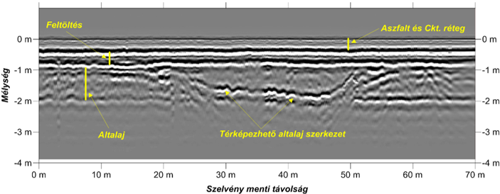
The methods can be reliably applied for investigating the (sub)structure and quality of roads, pavements, sidewalks and for geotechnical works. As the result of our measurements the thickness of the asphalt and underlying (un)bound layers can be determined. Horizontal and vertical inhomogeneities, fracture systems and detachment surfaces can be mapped, providing a cost-effective way to delineate and easily repair any damage or construction failures not visible on the surface. In case of newly built roads the measurements can be drawn into the quality assurance system.
Near-surface underground utilities and other buried objects can also be detected and delineated with high precision.
Deeper structural surveyings (2-10 meters) make it possible to investigate the quality of the sub-base and the subgrade as well. We can provide qualitative assessment regarding soil compaction, while potential cavities, clay lenses or blocks of harder rock formations can also be determined. The depth of the bedrock as well as its mechanical parameters required for foundation, sub-base and buttress construction can be calculated.
These types of surveyings provide opportunities to repair the critical sections, preventing accidents or unexpected obstacles, which could significantly delay the construction works.