Digitization of Logs and maps
Integration of geological and geophysical data stored on paper or transparency sheets into subsurface and hydrocarbon interpretation projects is essential for a successful and effective geological exploration. Modern software packages are available for the integrated interpretations, however they require digital datasets.
Geomega provides quick and cost-effective digitization of graphical data most frequently used in geological explorations, whether they are geophysical well logs, maps or geological profiles. Decades of experience, stringent quality requirements, the use of state-of-the-art software and our precise quality control procedures guarantee the accurate, fast and cost-effective digitization.
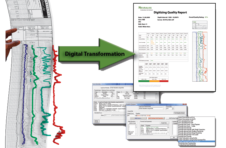
Visualization and interpretation of vintage, paper-based borehole-geophysical logs in modern processing softwares are only possible after digitization. During our semi-automated digitization workflow the challenges and irregularities coming from uneven vintage printing, irregular stretching of the paper through the years as well as from small movements during scanning are handled and corrected. This ensures correct depth and log values, which are fundamental prerequisites for an appropriate interpretation.
During the quality control procedures laid down in Geomega, the paper-based vintage geophysical logs are converted into digital formats recognizable by all modern evaluation softwares. We also undertake the correction, verification and petrophysical evaluation of previously digitized files, which are subject to digitization errors.
After integration of all well log datasets of the given borehole, the curves are provided in industry standard LAS, LIS or txt formats with a common nomenclature. The digital files also include the parameters of the curves.
Features:
- Color, monochrome or greyscale input files
- Flexible distortion management
- Neural network-based automatic curve tracking
- Tracking of continuous, dashed, faint or blurred curves
- Handling of linear, multi-linear, logarithmic and backup scales
- As high as 1000m/h digitization speed
- Industry-standard LAS, LIS output formats
- Common curve nomenclature
It is essential and important for any geological exploration project that geographic maps / objects are available in digital format containing coordinates (georeferenced data system). Without geo-referencing, the maps cannot be embedded into a GIS system, and no additional coordinate-based information can be overlain.
During georeferencing of raster files (i.e., image format maps), geographic coordinate pairs are assigned to the pixels of the digital image in order to be able to insert the map into the GIS database used for the exploration.
Geomega has large experience in handling and transformation of distorted images, we have a proprietary software developed for this purpose. Image transformation is required, because in the digital image file to be georeferenced the map is always slightly rotated and distorted due to the inevitable irregularities coming from the scanning.
The georeferenced map resulting from the image transformation is converted into geotif format (or tif + tfw navigation file), which can be properly inserted into a GIS system or vectorization software.
Vectorization of georeferenced maps provide extreme flexibility in the field of data display, storage and transfer of geographic information.Geomega has decades of experience in digitizing geological maps and profiles, and this experience is often crucial, whether it be hydrological, topographic or ground maps.
Geomega undertakes the scanning and georeferenced digitization of paper maps. In all cases, the digitization is performed in a quality-controlled way, by checking the coordinates of the digitized and the original map, and then converting the digitized data system into the selected vector files. If required, the vectorized database generated during the digitization of contour maps is interpolated to digital grids.
In Geomega we routinely digitize various maps including:
- Elements of topographical maps (natural protection boundaries, protected forest, roads, etc.)
- Topographical, depth, geological or geophysical contour maps
- Values of geophysical measurement grids
- Seismic acquisition maps
- Geological and fault maps
- Geological profiles