Archeological surveying
Non-destructive surface geophysical measurements provide a quick and cost effective way during the exploration for buried archeological objects.
Remnants of buildings or bridges, graves, larger artifacts having contrasting physical properties compared to their surrounding and other ancient objects can be identified. Compared to artificial fill-up the original soil layers usually have markedly different resistivity and physical properties, allowing us to identify and delineate disturbed areas where historical human interference possibly occurred (trenches, graves etc.).
For surveying large areas the electromagnetic and magnetic methods are the most effective. These methods have proved to be very powerful in archeological exploration, museums regularly use our results. Geomega has decades of experience in both methods.
Ground radar (GPR) is a high precision measurement technique providing also depth information. Compared to the magnetic and EM methods it requires a more complex processing, but provides more detailed results. In certain cases it is advisable to combine the various methods.
Secrets of Danube: Archeological exploration near Szalki-island
In 2016, water seismic archeological investigation was implemented at the Danube near Dunaújváros to aid the diving archeological search led by Dr. Attila János Tóth.
Two places were known apriori where remnants from Roman age could be found. Furthermore, archeologists found 7 m wide and 30 m long object looking like cigars based on sonar measurements and dives. These objects were created from wood and rock, filled with bricks. Further investigations became impracticable because of water drifting and low visual range. Water seismic acquisitions proved to be perfect choice.
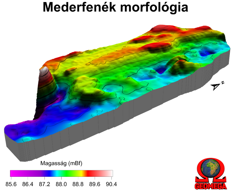
The figure below shows the map of the measured riverbed. The figure shows the cigar-shaped platform remnants. In addition to the platforms known in the northern part, there are two other, parallel, dredged platforms left in the northern area. And there are two further elevations in the southern part, and a third residue covered with sediment. Their longitudinal axis corresponds to the platforms in the northern area.
During the dives following the measurement, a limestone fragment with inscription and worn-out Roman inscription fragments were brought up. The inscription comes from the tombstone of a late Roman rider, but his age is unknown.
The remnants most likely come from a previous harbor or bridge.